
ماژول GSM/GPRS R800C
7,650,000
ریال
سرعت بسیار بالا و مکان یابی با قدرت زیاد
معرفی
GMS7-CR6 یک ماژول GPS فشرده است که برای طیف وسیعی از تولید کنندههای محصولات اورجینال (OEM) که در آن یکپارچه سازی سریع و ساده سیستم و با کمترین ریسک توسعه اهمیت دلرد مورد نیاز است. گیرنده به طور مداوم ماهواره های در محدوده دید خود را ردیابی می کند و اطلاعات مکان یابی ماهواره ای دقیقی را ارائه می دهد. GMS7-CR6 برای برنامه های کاربردی نیازمند به عملکرد بالا، قیمت کم و حداکثر انعطاف پذیری، بهینه شده و توانایی ذخیره اطلاعات مکان یابی شامل طول و عرض و ارتفاع جغرافیایی، سرعت و UTC تا 6 ساعت را داراست. تاریخچه مکان ها می تواند به صورت خروجی به نرم افزار های مکان یابی مانند google earth یا TrackMaker داده شود.
مشخصات
دارای 48 کانال ردیابی
حساسیت ردیابی برابر با -147dBm است
دقت CEP برابر با 2.5m است
SBAS (WAAS,EGNOS) را پشتیبانی میکند.
پشتیبانی از تابع SAGPS
جریان ردیابی کمتر از 29 میلی آمپر است.
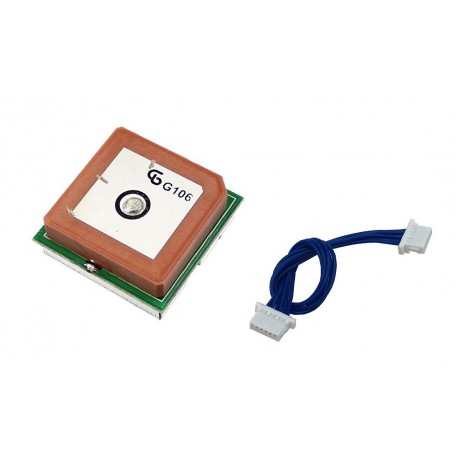
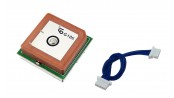
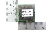
ابعاد: 20mm*20mm*9.20mm
آنتن سرخود
راه اندازی اولیه (به طور متوسط):
HOT start: 1 sec
COLD start : 34 sec
نرخ به روز رسانی : به طور استاندارد ۱Hz (به طور سفارشی ۵Hz/10Hz )
زمان مورد نیاز برای پیدا کردن ماهواره در اولین روشنایی ۳۵ ثانیه
پروتکل ها : NMEA-0183 V3.01 GPGGA, GPGLL, GPGSA, GPGSV, GPRMC,GPVTG, GPZDA ۴۸۰۰/۹۶۰۰/۱۹۲۰۰/۳۸۴۰۰ baud, ۸, N, 1
ولتاژ ورودی :3.3~6 (+/- 10%)
خروجی RS232
وزن : 14g
Introduction
GMS7-CR6(SIRF-IV) Fast Acquisition Enhanced Sensitivity 48 Channel GPS Sensor Module The GMS7-CR6 is a compact all-in-one GPS module solution intended for a broad range of Original Equipment Manufacturer (OEM) products, where fast and easy system integration and minimal development risk is required. FEATURES The receiver continuously tracks all satellites in view and provides accurate satellite positioning data. The GMS7-CR6 is optimized for applications requiring high-performance, low cost, and maximum flexibility; suitable for a wide range of OEM configurations including handhelds, sensors, asset tracking, PDA-centric personal navigation system, and vehicle navigation products. 48 track verification channels Tracking sensitivity -163dBm Acquisition sensitivity 147dBm Cold start < 34 seconds 2.5m CEP accuracy SBAS (WAAS, EGNOS) support Support SAGPS function Support 6 hours data logger. Log data can be exported to mapping software such as Google Earth and TrackMaker Logging data interval programmable: by time or distance < 29mA with Tracking current Dimension: 20x 20 x 9.20 mm The GMS7-CR6 is capable of keeping up to 6 hours records or positions, including longitude, latitude, speed, UTC, and tag data. The location histories can be exported to mapping software such as Google Earth or TrackMaker Its 48 parallel channels and provide fast satellite signal acquisition and short startup time. Acquisition sensitivity of 147dBm and tracking sensitivity of 163dBm offers good navigation performance even in urban canyons having a limited sky view. Satellite-based augmentation systems, such as WAAS and EGNOS, are supported to yield improved accuracy. Besides it also supports A-GPS function and fixed in a short time. The RS232-level serial interface is provided on the interface connector. The supply voltage of 3.3V~6.0V is supported. Users can modify NMEA sentences or Binary code by the extra flash memory.
Specification
Built-in RS232C level converter
Communication conditions: 9600bps, 8, N, 1
NMEA-0183(V3.01) WGS-84
Power supply: DC3.3~6V
Indicator: 1 red LED x 1, the satellite captured Then, it blinks about every 1 second (lights off immediately after turning on the power).
6-pin connection cable included
* The dielectric antenna of the main unit has been adjusted for the best reception. Do not touch it as it looks like a scratch because it is a mark of this trimming.


